|
|
|
|
Contribution of intra-cloud lightning monitoring for improvinghe nowcasting of severe thunderstorm precipitations
Philippe Richard
Dimensions, 7 Europarc Sainte Victoire, 13590 Meyreuil, France.
Abstract: The intra-cloud lightning monitoring is achieved by high frequency electromagnetic detection and interferometric localisation of all electrical discharges which occur within the storm cloud as it builds up and grows. The physical principle is that all along the development of a thunderstorm cell, the internal electrical activity of the thundercloud (internal micro-discharges and intra-cloud lightning flashes), is closely related to the different stages of evolution of the cell and to its severity. These discharges are a precursor phenomenon allowing to identify and locate a storm cloud up to several hours before it reaches the intense precipitation phase.
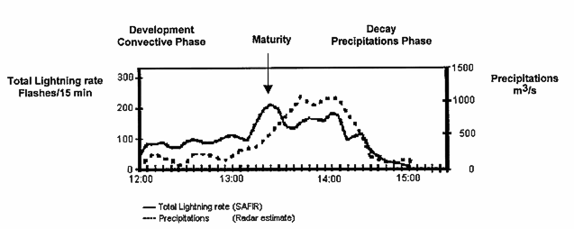
Figure 1: Example of time evolution of total lightning activity and precipitation in a thunderstorm cell. During the development (12:00 to 13:00) the intra-cloud lightning rate confirms that the storm cell is in a convective phase. Maximum vertical development and maturity are indicated by the peak intra-cloud lightning rate, the immediate decrease in intra-cloud lightning rate indicates the beginning of the precipitation phase. The persistence of a high infra-cloud lightning rate after maturity is indicative of the persistence of intense precipitation in the near future.
|